


Russian Jack Precinct, Anchorage Municipality, Alaska
About
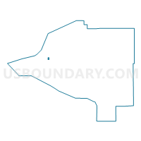
Outline

Summary
| Unique Area Identifier | 523206 |
| Name | Russian Jack Precinct |
| County | Anchorage Municipality |
| State | Alaska |
| Area (square miles) | 0.51 |
| Land Area (square miles) | 0.51 |
| Water Area (square miles) | 0.00 |
| % of Land Area | 100.00 |
| % of Water Area | 0.00 |
| Latitude of the Internal Point | 61.20246120 |
| Longtitude of the Internal Point | -149.78589080 |
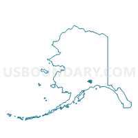
Maps

Graphs
Select a template below for downloading or customizing gragh for Russian Jack Precinct, Anchorage Municipality, Alaska


Neighbors
Neighoring Voting District (by Name) Neighboring Voting District on the Map
- Chester Valley Precinct, Anchorage Municipality, AK
- College Gate Precinct, Anchorage Municipality, AK
- East Anchorage Precinct, Anchorage Municipality, AK
- Nunaka Valley Precinct, Anchorage Municipality, AK
- Reflection Lake Precinct, Anchorage Municipality, AK
- South Mountain View No. 2 Precinct, Anchorage Municipality, AK
- University No. 1 Precinct, Anchorage Municipality, AK
- Wonder Park Precinct, Anchorage Municipality, AK
Top 10 Neighboring County Subdivision (by Population) Neighboring County Subdivision on the Map
Top 10 Neighboring Place (by Population) Neighboring Place on the Map
Top 10 Neighboring Unified School District (by Population) Neighboring Unified School District on the Map
Top 10 Neighboring State Legislative District Lower Chamber (by Population) Neighboring State Legislative District Lower Chamber on the Map
- State House District 20, Mountain View-Wonder Park, AK (18,540)
- State House District 19, Muldoon, AK (17,804)
- State House District 21, Baxter Bog, AK (16,303)
- State House District 22, University-Airport Heights, AK (16,126)
Top 10 Neighboring State Legislative District Upper Chamber (by Population) Neighboring State Legislative District Upper Chamber on the Map
Top 10 Neighboring 111th Congressional District (by Population) Neighboring 111th Congressional District on the Map
Top 10 Neighboring Census Tract (by Population) Neighboring Census Tract on the Map
- Census Tract 8.01, Anchorage Municipality, AK (7,323)
- Census Tract 17.01, Anchorage Municipality, AK (6,843)
- Census Tract 7.01, Anchorage Municipality, AK (5,949)
- Census Tract 17.02, Anchorage Municipality, AK (5,258)
- Census Tract 8.02, Anchorage Municipality, AK (4,407)
- Census Tract 16.02, Anchorage Municipality, AK (4,224)